Product Code Database

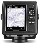
The device has a 5"" VGA display that provides distinct target separation, day/night visibility and easy to navigate user interface. The GPSMAP 547 also allows sonar recording which coordinates the timing of the sonar return with your boat's position and saves digital information on the map. This ensures accurate and precise marking of the waypoints. It additionally features wi-fi connectivity and comes preloaded with U.S. coastal and inland mapping. GPSMAP 547 Features: GPS Chartplotter, Part Number: 010-01093-00, 5"" VGA Color Screen, 10Hz GPS/GLONASS Receiver -Updates Position & Heading Up To 10 Times Per Second -10 Times Faster than 1 HZ GPS, HD-ID Sonar -Sonar Recording -Better Separation & Definition of Images -Accurate & Precise Marking of Waypoints, Wi-Fi Connectivity, Bluetooth Wireless Technology, Easy to Navigate User Interface, Dual microSD Card Slots, Preloaded Software -U.S. Coastal & Inland Mapping, 5000 Waypoints, 50, 000 Point Active Track Log & 50 Saved Tracks, XM WX Satellite Weather Capable, AIS Support -Track Target Ships' Position, DSC Support -Displays Position Data from DSC Capable VHF Radio, NMEA 0183 Compatible & NMEA 2000® Certified, Sun & Moon Information, Audible Alarms, Mounting Options: Swivel, Flush or Flat Mount, Waterproof to IPX7 Standard, Included FREE: Power / Data Cable, Tilt/Swivel Mount, Flush Mount Kit, Protective Cover"
|