Product Code Database

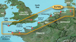
It also includes coverage of Hamburg, Ger. Amsterdam and Rotterdam, Nld. as well as the Atlantic coast of France including Dunkerque, Calais, and Brest. With BlueChart g2 card, you'll have access to detailed mapping capabilities which include standardized depth contours, smooth data transition between zoom levels, harmonious transition across chart borders, and reduction of chart discontinuities. Bluechart g2 HEU705L Features: Hamburg to Brest Digital Map, Covers Hamburg to Brest, Shaded Depth Contours, Safety Shading, Intertidal Zones, Spot Soundings, Smooth Data Transition Between Zoom Levels, Fishing Charts, Harmonious Chart Borders Transition, Reduced Chart Discontinuities, 2-D Direct Overhead View, 3-D Over-the-Bow View, Port Plans, Tides, Wrecks, Restricted Areas & Anchorages"
|