Product Code Database
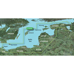
"Garmin Bluechart g2 Vision - VEU505S, Baltic Sea East Coast Brand New Includes One Year Warranty, Product # 010-C0849-00 (SD Card) The Garmin Bluechart g2 Vision VEU505S navigation software contains information of coasts of Estonia, Latvia, Lithuania, Russia, and Poland from Narva-Joesuu, Est
To Rugen, Ger. It also includes coverage of Gotland, Gulf of Riga, Kaliningrad, Rus. and the Polish cities of Gdansk and Szczecin. With BlueChart g2 card, you'll have access to detailed mapping capabilities which include standardized depth contours, smooth data transition between zoom levels, harmonious transition across chart borders, and reduction of chart discontinuities. The Bluechart g2 Vision VEU505S includes all of the features of BlueChart g2 product with addition 3-D perspective above and below the waterline and Auto Guidance technology searches chart data to suggest the best passage to a destination. It gives high resolution realistic satellite images of the land and water with the aerial photos of ports, harbors, marinas, waterways, navigational landmarks and other POIs. Bluechart g2 Vision VEU505S Features: Baltic Sea, East Coast Digital Map, Covers Eastern Coast of Baltic Sea, High Resolution Satellite Images, Shaded Depth Contours, Aerial Photography - ""Real World"" Photos of Ports / Harbors / Marinas / Waterways / Navigation Landmarks /Points of Interest, Smooth Data Transition Between Zoom Levels, Auto Guidance Technology - Searches Chart Data to Suggest the Best Passage to a Destination, 2-D Direct Overhead View, Mariner's Eye View, Fish Eye View - 3-D View Above & Below Waterline, Safety Shading, Intertidal Zones, Spot Soundings, Fishing Charts, Harmonious Chart Borders Transition, Reduced Chart Discontinuities, Port Plans, Tides, Wrecks, Restricted Areas & Anchorages"
|
|