Product Code Database
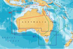
"Navionics Platinum 61P - Australia South Brand New Includes One Year Warranty, Product # CF/61PP (CF Card) The Navionics Platinum 61P is the multi-dimensional Platanium marine chart that contains information of Australia South which covers Australia South, Tasmania
From Perth to Wollongong Harbour. Including Great Australian Bight, Spencer Gulf, Gulf ST, Vincent, Kangaroo Island, Bass Strait, Furneaux Group, King Island, Melbourne and Adelaide. The Platinum charts covers the world providing navigators and fisherman with all the necessary data for safer and easier navigation. The Platinum 61P feature the full seamless & IC technology, user selectable safety depth contours, major coastal road networks, high definition fishing details, including dynamic tides and currents, panoramic pictures and more. Platinum 61P Features: Australia South Marine Chart, Covers Australia South, Tasmania From Perth To Wollongong Harbour Including Great Australian Bight, Full Seamless & IC Technology, Paper Chart-Like Detail, Panoramic Pictures, 3-Dimensional View, User-Selectable Safety Depth Contours, High-Definition Fishing Details, Satellite Photo Overlay, Navaids w/ Xplain&trade, Major Coastal Road Networks, Coastal Points-Of-Interest -Banks, Hotels, & Restaurants, Geo-Referenced Coast Pilot Books, Dynamic Tides & Currents, Enhanged Port Services, NavPlanner / PC Software Compatible, For Raymarine Models : A Series: A50, A50D, A57D, A70, A70D, C Series : C120, C70, C80, C120W, C140W, C90W, E Series : E120W, E140W, E90W, G Series : GPM400, RC Series : RC 400, RC 435, RC 435i"
|