Product Code Database
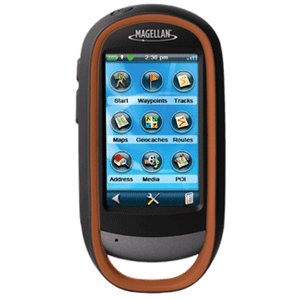
It creates a waypoints, record tracks, and route from point to point. This device helps in recording with its 3.2 mega-pixel camera that can be displayed on your computer. Its microphone and speaker enables outdoor enthusiasts to record geo-referenced images and voice notes. The eXplorist 710 provides 2D or 3D viewing angles and covers the globe with details roads and land use areas. The eXplorist 710 has a 3-axis electronic compass and barometric altimeter that shows the exact direction and the accurate altitude of the sea-level with the built in sensors. With the help of the barometer you can keep the track of the weather conditions. It has a 3.0"" touch screen and button controls for easy access and an paperless geocaching in which one can view more than 20 unique characteristics of each cache and view, search, filter on the device. This device comes with the world edition pre-loaded map that includes contour lines, land use areas, trails, waterways, and points of interest. eXplorist 710 Features: GPS Handheld Navigation System, 3"" Touchscreen, Core Outdoor Navigation, 3.2 Mega-Pixel Camera for Recording, Superior Maps w/ 3D Perspective View, 3-axis Electronic Compass, Barometric Altimeter, Paperless Geocaching, OneTouch&trade Menu, 3GB Internal Memory, World Edition Pre-loaded Map, Summit Series USA, Detailed Topographic Map Based on 1:24, 000 Scale Source Maps, City Series USA, Turn by Turn Navigation Through the City Streets, 15 Hours of Battery Life"
|

