Product Code Database
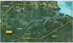
"Garmin VSA009R G2 Vision f/Amazon River - Micro SD Brand New Includes One Year Warranty, The Garmin VSA009R G2 navigation software contains information of Amazon River with auto guidance technology
The VSA009R has on-chart position in relation to navaids, coastal features, restricted areas. This software helps you get the detailed marine cartography that provides convenient viewing of nautical content. It allows you to see your vessel's precise, high-resolution imagery, aerial photos of ports, harbors, marinas, landmarks, other points of interest and more. The BlueChart G2 VSA009R features fishing charts to help scope out bottom contours and depth soundings with high-resolution satellite imagery. This unit is compatible with HomePort&trade software that lets you use BlueChart data to conveniently plan and organize routes from your computer before your trip. BlueChart G2 VSA009RFeatures: Product # 010-C1066-00, G2 Bluechart - Amazon River, Shows Everything From Shaded Depth Contours & Coastlines, High Resolution Satellite Imagery, Aerial Real world Photos Ports, Harbors, & Other Points Of interest, Auto Guidance Technology -Suggest Best Passage To A Destination, Spot Soundings, Navaids, Port Plans, Wrecks & More, Detailed Marine Cartography, Seamless Transitioning Between Zoom Levels, MarinerEye View 3-D Perspective -Quick, Reliable & Easy Position Fix, FishEye View 3-D Perspective -Underwater View That Visually Represents The Sea Floor, Safety Shading, Fishing Charts, Choice of Standard 2-D Direct Overhead or 3-D, Compatible w/ HomePort&trade"
|