Product Code Database
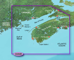
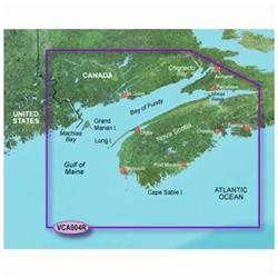
"Garmin Bluechart g2 vision VCA004R, Bay of Fundy Brand New Includes One Year Warranty, Product # 010-C0690-00 (SD Card) Replaces: Product # 010-C0324-00 (microSD/SD Card) Product # 010-C0003-00 (Datacard) The Garmin Bluechart g2 Vision VCA004R navigation software contains information of Bay of Fundy with detailed coverage of coasts of Maine and New Brunswick from Machias Bay to Saint John including western Nova Scotia and from Heckmans Island to Halifax
With BlueChart g2 Vision card, you'll have access to detailed mapping capabilities which include standardized depth contours, smooth data transition between zoom levels, harmonious transition across chart borders, and reduction of chart discontinuities. The Bluechart g2 vision VCA004R offers the most realistic mapping display Garmin has ever offered. It includes premium features, such as true 3D-view perspective above and below the waterline, auto guidance, high-resolution imagery, and aerial reference photography providing ""real picture"" aerial photos of ports, harbors, marinas, waterways, navigation landmarks and other points of interest. Bluechart g2 Vision VCA004R Features: Bay of Fundy Digital Map, Covers Machias Bay to Chignecto Bay & Minas Basin, from Digby to Halifax, High-Resolution Satellite Imagery, Standardized Depth Contours, Aerial Reference Photography - ""Real World"" Photos of Ports / Harbors / Marinas / Waterways / Navigation Landmarks / Points of Interest, Smooth Data Transition Between Zoom Levels, Auto Guidance Technology - Includes Tides / Currents / Marine Services / Coastal Roads / Points of Interest, Mariner's Eye View, Fish Eye View - 3D-View Above & Below Waterline, Harmonious Chart Borders Transition, Reduced Chart Discontinuities"
|